MapX Platform
MapX is an innovative, interactive, and open-access cartographic platform that enables global users to access, visualize, and interact with spatial datasets from diverse databases across international, national, and local scales. The platform is organized into distinct projects containing multiple thematic categories. The Plan Bleu Observatory is hosted within MapX under the "WESR: MEDITERRANEAN" project and features over 435 interactive maps with related statistics organized across 26 categories at Mediterranean scales.
Through MapX's map viewer, users can simultaneously visualize quantitative and qualitative datasets along with their titles, legends, symbologies, abstracts, and metadata. Users can deepen their analysis by interacting with statistical representations including histograms, linear regressions, and pie charts. The platform also offers temporal analysis capabilities through interannual and monthly time sliders to explore map evolution over time. Additionally, users can combine and overlay different maps without requiring specialized GIS skills.
By hosting the Plan Bleu Observatory, MapX directly contributes to data sharing and project dissemination while strengthening Mediterranean networks of data practitioners across diverse fields including biodiversity, climate, water resources, tourism, and demography.
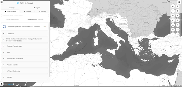 click to view full size
 Implementation
Within Plan Bleu's observatory framework, MapX serves as the primary tool for monitoring environmental conditions and sustainable development progress across the Mediterranean region. The platform supports all of Plan Bleu's thematic activities and provides an innovative means of communicating and sharing information with target audiences. Internally, all projects benefit from enhanced visibility through cartographic representations built in MapX, with these functionalities being actively utilized during participatory events including international workshops, plenary sessions, and side-events.
The Observatory serves as the operational foundation for visualizing the Mediterranean Strategy for Sustainable Development (MSSD) by providing and maintaining the MSSD's Indicators Dashboard within MapX. Additionally, datasets accessible through the Plan Bleu Observatory support various research projects conducted by Plan Bleu.
Tourism-related project results are integrated and showcased within MapX, facilitating international collaboration. Notable examples include the Blue Tourism Initiative and past Interreg projects such as Destimed Plus and NaTou4CChange. A dedicated tourism thematic category has been established in MapX, featuring 55 maps that can be combined with other cartographic representations available on the platform.
Policy Hubs
Target Groups
Replicability conditions
MapX enhances replication opportunities through several key functionalities beyond basic map visualization. The platform facilitates knowledge transfer through its URL sharing feature, enabling users to easily distribute their analyses with other experts and stakeholders. The Map Composer functionality allows users to create customized map layouts that can be exported in PNG format, supporting the documentation and dissemination of methodologies across different contexts. For institutions seeking to replicate Plan Bleu's observatory approach, MapX offers advanced publication and editing capabilities through partnership agreements with UNEP-GRID, providing the technical infrastructure necessary to establish similar environmental monitoring systems in other regions.